Stemming from an ongoing doctoral project in media anthropology concerning extractivism, (social) ecologies, and settler-indigenous relationships in subarctic Québec, this multimodal paper explores landscape memories and archival ecologies in the mining town of Schefferville and the adjacent Innu community of Matimekush-Lac John, Eastern Canada. Based on visual material collected during long-term ethnographic fieldwork conducted in the region in 2022 and 2023, it critically examines the complex links between extractivism, visuality, (settler-colonial) governmentality, and indigenous land dispossession. More specifically, building on research in anthropology, media theory, and cultural studies, it proposes the concept of visual extractivism to analyse a visual archive produced during the latter half of the 20th century to support and document mining operations in and around Schefferville. To conclude, this paper outlines ways in which remediation strategies—both conceptually and creatively—offer alternatives to exclusionary narratives of visual extractivism.
Key Words subarctic Québec, archive, (visual) extractivism, geology, settler colonialism, remediation
Special Theme
Landscape Memories, Archival Ecologies
Remediating Visual Extractivism and the Geological Archive: Multimodal Perspectives from Subarctic Québec
(Published March 27, 2025)
Abstract
Introduction
Since spring 2022, I have conducted ethnographic fieldwork in the mining region of Schefferville and the adjacent Innu community of Matimekush-Lac John, Eastern Canada. Both communities are located in the interior of the Québec-Labrador Peninsula, on the northern border between the provinces of Québec and Newfoundland and Labrador. The region lies at the heart of Nitassinan, the ancestral, unceded, and unrecognised territory of the Innu people. 1) 2) My research sits at the intersection of mining, ecologies, and settler-indigenous relationships, focusing particularly on the ongoing, multilayered impacts of extractive operations on the territory and the human and more-than-human communities inhabiting it. While grounding these impacts in the specific context of Schefferville and Matimekush-Lac John, the project also considers multiple scales and sites, seeking to broaden the discussion to the entanglements between extraction, settler colonialism, and land dispossession in Québec, Canada, and, more largely, North America. To this end, it engages with the concept of extractivism (Gudynas 2021; Acosta 2020) to address the colonial nature of settler relations and the multiple dimensions—beyond extraction itself—of this capacious and expanding concept (Chagnon et al. 2022). By referring to past and present entanglements between resource extraction, global flows, and local consequences, extractivism provides a framework in which mining, settler colonialism, and land dispossession are understood in relation to one another (Gomez Barris 2017). Thus, my research critically addresses the consequences that extractivism has had, and continues to have, on (indigenous) lands, human and more-than-human communities, and local ecologies. These discussions are approached both ethnographically and multimodally and are kept in constant dialogue with the realities on the ground. Through fieldwork encounters, exchanges, and shared experiences, I convey everyday stories of care, resistance, and life—life that persists despite or alongside extractivism’s disruptions, dispossessions, and losses.
This multimodal study adopts a specific angle on the research outlined above. Theoretically, it engages with recent anthropological debates on the complex relationships between extractivism and the natural sciences, notably geology. Building on research that focuses on the visual dimension of extractivism (Gomez Barris 2015, 2017; Serafini 2023) and the entanglements between (settler-colonial) statehood, visuality, and governmentality (Scott 1998; Braun 2000), it foregrounds the concept of ‘visual extractivism’ to explore how specific images primarily ‘operate’ (Parikka 2023) and reproduce consequences as akin to extractivism itself. These debates will be considered in relation to a specific archive, produced in the latter half of the 20th century, which documented and sustained mining operations in and around the mining town of Schefferville. Held in a disarray at the location I inhabited during my fieldwork—the semi-abandoned compound of the former McGill Subarctic Research Station (MSARS) in Schefferville—the archive contains diverse media, including books and texts, maps, scientific reports, graphs, meteorological data, rocks, geological cores, herbaria, and soil samples. This paper focuses particularly on images that document mining-related operations and support geological research in the Schefferville area: aerial views, large panoramic perspectives, smaller analogue photographs and polaroids, and occasional photographs of events associated with the life of the mining town. By critically examining these images through the lens of visual extractivism, this paper questions how the MSARS archive materially and discursively participates in settler colonialism and land dispossession by commodifying territories (Gomez Barris 2017), excluding local knowledge (Scott 1998), and ultimately rupturing indigenous relationships with land and territories (Gomez Barris 2017; Brynne Voyles 2015; Keeling and Peyton 2017). Throughout its development, this paper also engages with remediation, both conceptually and multimodally, as a creative practice to experiment with strategies that intervene in and partially remediate the MSARS archive (Bolter and Grusin 1999; Keeling and Beckett 2019; Chatterjee forthcoming). Thus, visual interventions— remediations —are performed on some of the archival material, experimenting with how the term can function both conceptually and practically. Remediation practices also guide the film excerpt included in this paper, which engages with audiovisual material gathered during fieldwork. The paper’s conclusion defines the concept of remediation in detail and elaborates on its potential to challenge visual extractivism and dominant settler narratives. 3)
Schefferville and Matimekush-Lac John: How Extractivism Dispossesses
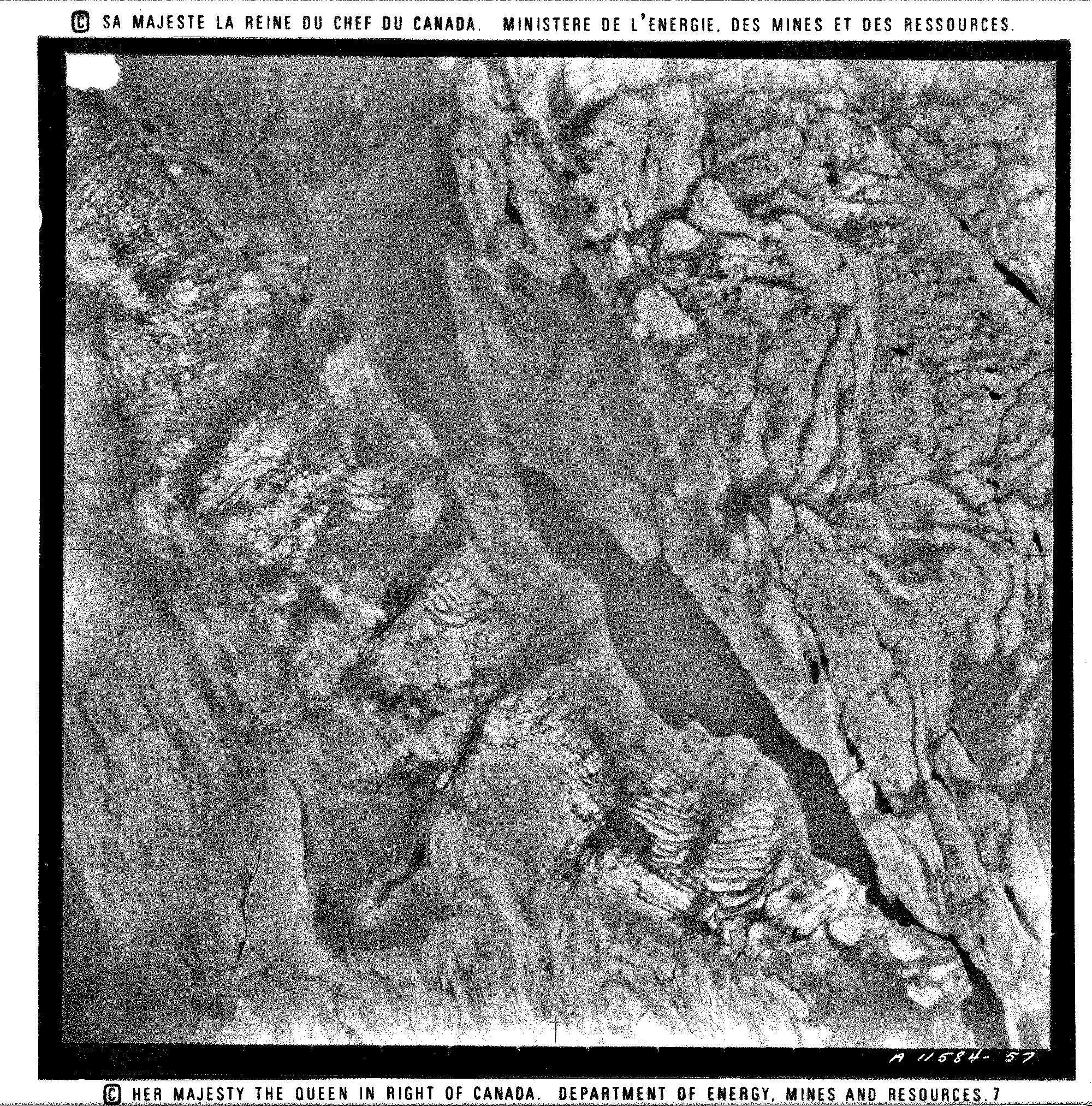 Figure 1 This black-and-white image was lying in a pile with hundreds of others in one of the several abandoned buildings of the MSARS, Schefferville, Northern Québec. Following is a fieldwork vignette meant to accompany the picture. Here the vignette operates as a “remediation” strategy in which it thickens the image and suggests directions to reorientate its immediate reading.
When L., one of my main fieldwork interlocutors, invited me for dinner at her mother’s place, I brought this picture with me. L. had always been curious about the many objects abandoned at the Research Station, so from time to time, I would bring some along, either to look at together or for her use. When I arrived at her mother’s house, everyone was ready for the upcoming bingo radio session. I pulled out the photograph and I showed it to L. ‘Look what I found’, I said. She gave a quick glance at the black-and-white image asked me what it was. She then turned to her mother, asking Neka to look at ‘this old picture’ and handed her the photograph. ‘It says something about the Queen, “la Reine”. She came to Schefferville once, right?’ she asked her mother.
Neka took the photo and looked at it closely, without saying anything. She then started talking, recalling how the Queen had once come to visit the mines, to visit ‘the white people and us’. She had wanted to meet the Queen so badly, as she had been her idol. Neka told us how she still remembered the first time she saw a picture of the Queen. It was during a collective meal her mother had prepared in the forest when she saw a picture of a woman with a crown on a chocolate box. She asked her mother who that woman was, and her mother replied, ‘This is our Queen’. From that moment on, Neka could not stop looking at that picture, and every night she would pray for the Queen. After finishing her story, L.‘s mother placed the picture on the table and shifted her attention back to the bingo chart in front of her.
‘It’s a photo from around here, of the woods, from a plane. There are so many of them back at the station’, I said after a while, curious to see if someone would add something. L. took it into her hands again, looking at it sceptically, unconvinced by my words. ‘I don’t know; I can’t recognize anything, and anyway it’s all black-and-white!’ she said, her words followed by her classic, vigorous laugh.
The above is a transcription of a fieldwork note I took in Schefferville and Matimekush-Lac John. That evening, I visited a house in Matimekush and decided to bring a photograph from the MSARS to share with some of my interlocutors. Technically, this method is called ‘photo elicitation’ and has a long-standing tradition in visual anthropology (Collier and Collier 1986). People’s reactions to the photograph still inhabit my memory as a marking moment in my fieldwork experience, crystallising the entanglements between the MSARS archive and the layered ambivalences and complexities of settler colonialism. Furthermore, it explicitly exposes the different levels of understanding and relation to territories between the MSARS archive images and the memories and narratives of the local Innu inhabitants. More specifically, the series of aerial photographs that supported research activities at the MSARS exemplify a specific ‘geological way of seeing’ that characterised Canada’s late Victorian period and contributed to forms of legibility and (settler) governmental rationality in its northern territories (Braun 2000). By privileging measurement and calculation above all, operationality, in Parikka’s terms, this photograph produces a very narrow, ‘orderly and clean’ view of reality that both shapes and is shaped by the needs of the settler state and its corporate ramifications (Scott 1998). However, by operating abstraction and pursuing (settler) legibility, it creates ruptures that render territories fundamentally unrecognisable and unrelatable to their own local inhabitants. Thus, by excluding local, indigenous knowledge and reconfiguring territories to meet extractivist needs, the MSARS image archive intervenes in the world, whereby it materially and discursively participates in the settler colonial project, resulting in land dispossession and settler reterritorialisation (Brynne Voyles 2015, 2021; Gomez Barris 2017). In the case of the aerial photograph presented above, this intervention is most visible through its copyright, which reaffirms Crown ownership over the territory, negating any form of local and embodied memory, and, in this specific case, Innu territoriality.
Schefferville is situated in the vast territory shared by the Canadian provinces of Quebec and Newfoundland and Labrador. The original settlement, Burnt Creek, was built in the heart of the peninsula’s boreal forest, towards the southern end of a wide, mineral-rich geological formation known as the Labrador Trough. Expanding from the initial settlement, Schefferville was incorporated in 1954 as a company town by the Iron Ore Company of Canada (IOCC), a private mining company whose ownership was shared by various Canadian and U.S. firms. 4) The town’s creation was part of a larger governmental effort to develop and ‘tame’ the ‘wild’ and ‘deserted’ territory stretching across the Québec-Labrador Peninsula—a territory that had, since its European discovery, been considered one of North America’s harshest and most remote (Bradbury 1979; Bradbury et al. 1983). To support these efforts, the federal and provincial government created and promoted a favourable legal framework that encouraged mining companies to carry out prospecting and exploration activities, and later to invest and create towns, mines, and transportation infrastructures (Bradbury 2005). From the perspective of the federal and provincial governments, Schefferville’s foundation in 1954 was a stepping stone in opening an extractive frontier in a territory considered empty, wild, and extremely underdeveloped.
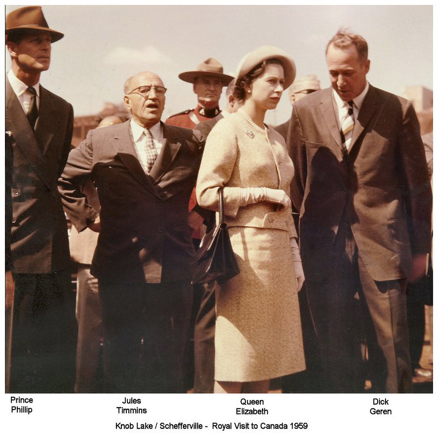 Figure 2 Several photographs document the Queen’s visit to Schefferville in 1959. In the image above, the Queen is accompanied by Prince Philip and two of the IOCC’s founders: Jules Timmins and Richard Geren. I could not find photographs that include Schefferville’s native population. (Image author unknown)
During the first two decades of the mines’ inception, Schefferville was heralded as a ‘success history’ of the Canadian settlement of the northern regions of Québec and Labrador (Keeling and Sandlos 2015; High 2023). Its flagship role in Canadian state extension and economic development in the northern territories brought the Queen of England herself to visit Schefferville in 1959, during one of her royal visits to Canada.
However, Schefferville’s success was short-lived. In the 1980s, due to the global market crisis for iron ore, the region experienced a significant economic decline. The IOCC’s project in Schefferville failed, and its mines were shut down in 1983. Following the closure, the town was almost entirely abandoned, leaving the territory and native communities to face the long and complex aftermath of extraction. Today, due to various factors influencing the mining sector and global geopolitics, extractive operations have resumed in the Schefferville area. By reinvesting in and extending some of the pits and infrastructures left by the IOCC, other companies are now prospecting and extracting in the region (Rodon et al. 2022). Amid these renewed activities and transformations, the region’s territory, as well as its human and more-than-human inhabitants, continue to confront the consequences of extractivism.
In recent decades, scholars of settler colonialism have critically examined the fundamental role of extractive operations in the dispossession of indigenous lands, which, in the Canadian context, is a central feature of the colonial relationship (Keeling and Peyton 2017). By examining how the establishment of (northern) settlements and the exploitation of natural resources were integral to settler colonialism in Canada, researchers have shown how these intertwined processes actively shaped Canadian identity and landscape imaginaries, especially along northern frontiers, while simultaneously disrupting indigenous relationships with territories (Brynne Voyles 2015, 2021; Keeling and Sandlos 2015; Gomez Barris 2017). Furthermore, these settler imaginaries, based on development and extraction, did not involve consultation with indigenous people. On the contrary, ‘industrial colonialism’ (High 2023) is a form of negation of indigenous territorial rights, often carried out alongside the progressive sedentarisation, confinement, and assimilation of indigenous populations. 5) Far from being ‘a thing of the past’, scholars continue to critically examine contemporary settler-indigenous relationships in Canada as continuations of long-standing processes of land dispossession and settler reterritorialisations (Coulthard 2014; Simpson 2021; Keeling and Peyton 2017).
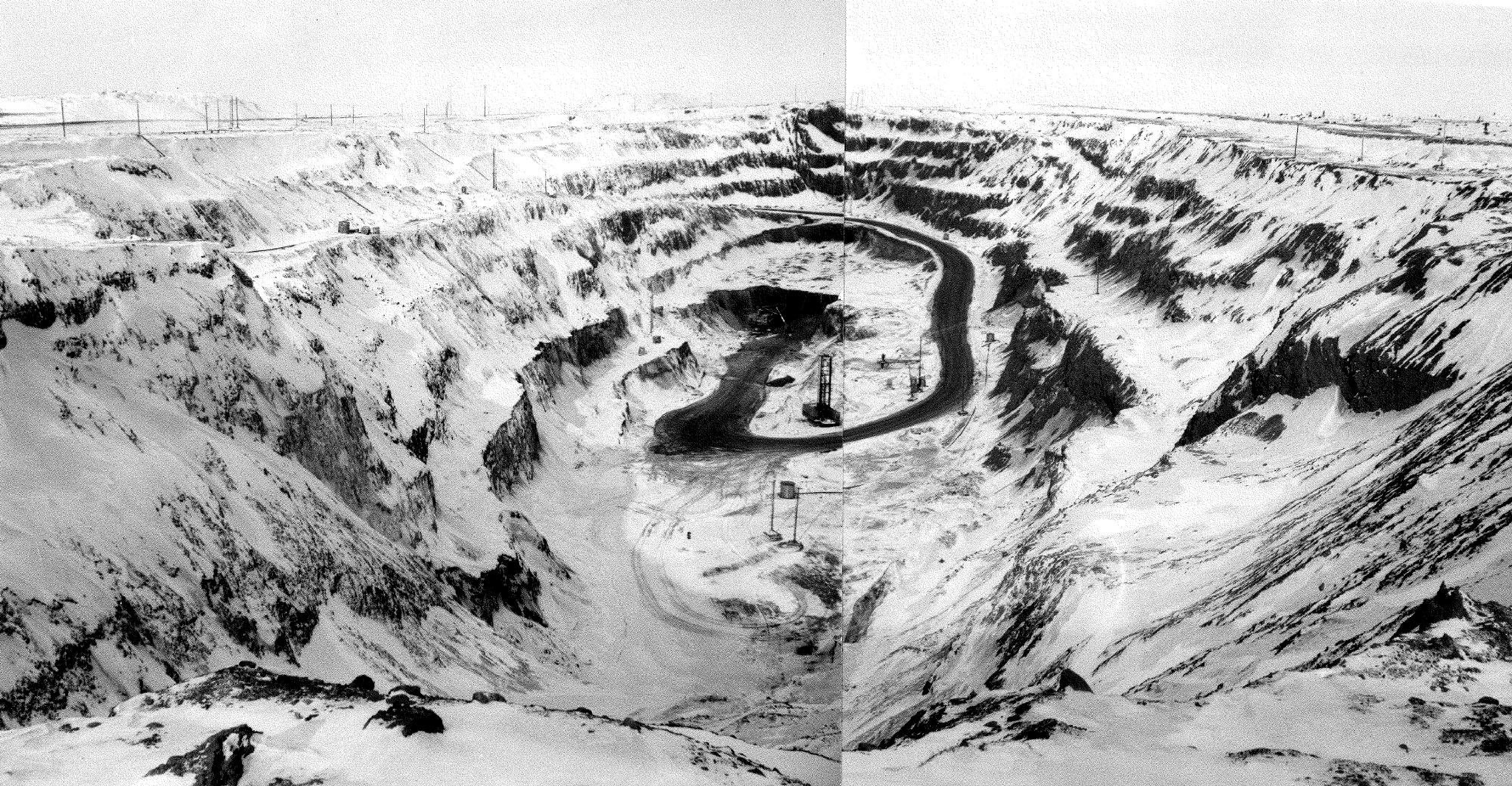
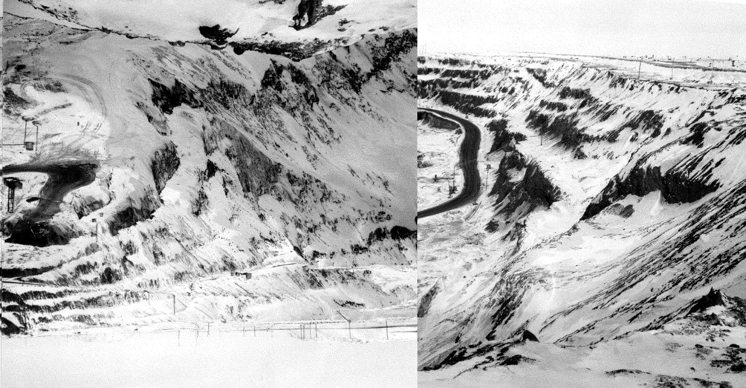 Figures 3 and 4 A panoramic view of an open mining pit in Schefferville during winter. The image – which was produced by juxtaposing different shots to create a broader horizon - portrays an empty landscape. Below is the same image, with its left portion cut and inverted along its vertical axis, revealing the line where the different shots were taken and glued together. The intervention – a subtle form of remediation – is from the paper’s author. (Images’ author unknown).
The MSARS and Its Visual Archive: Operational Images and (Settler) Legibility
During my fieldwork in Schefferville and Matimekush-Lac John, I inhabited the semi-abandoned buildings of the former MSARS. The station is referred to as ‘former’ because McGill University ceased its operations in 2018. Staying at the MSARS prompted me to consider the heritage of science as a crucial element shaping the relationship established between the West and the world since modernity. Being on the MSARS site, which is located on unceded indigenous lands, also led me to reflect deeply on the role of science and scientific research in the progressive establishment of settler statehood and governmentality, both in the region and more broadly. My reflections intensified as I encountered a variety of materials scattered throughout the compound’s buildings. These objects are remnants of decades of scientific research conducted at the MSARS prior to its gradual defunding and abandonment. Together, they form an archive that, beyond its materiality and physical boundedness to a place, exists as ‘a regime that consists of a set of practices materialised in papers, reports, images’ (Azoulay 2019).
The MSARS opened in 1954, the same year Schefferville was founded. The station was built on a small hill in the east, overlooking the town and located adjacent to what was then a military base combining an outpost of the Mid-Canada Line and a small detachment of the Royal Canadian Air Force. 6) The MSARS was established by McGill University’s Geography Department as an outpost of the University’s headquarters in Montreal, with the primary goal of bringing researchers into contact with a ‘formerly untouched’ part of the Canadian subarctic (Derbyshire 1961).
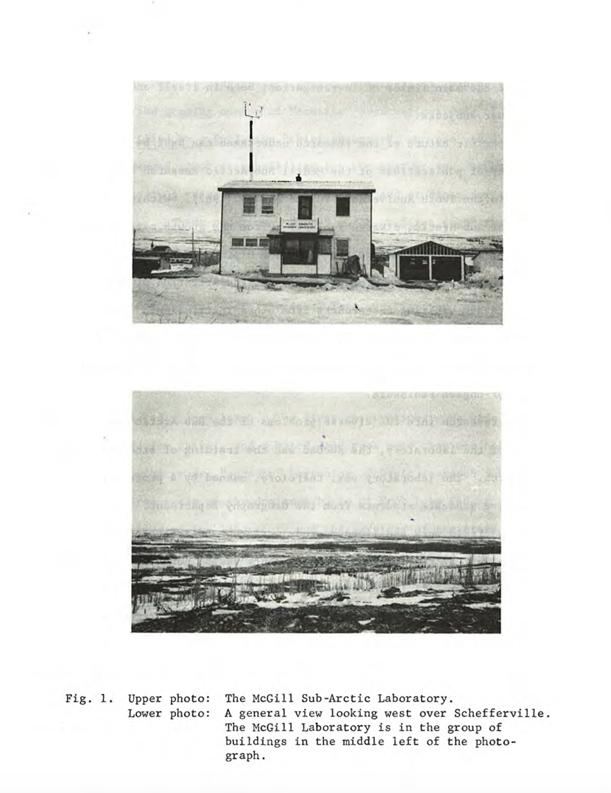 Figure 5 The archive hosted in the station also includes a series of images documenting the MSARS’s history itself. This history is narrated exclusively in relation to the development of the mining town and its associated mining activities, with no mention of the indigenous communities, including the Innus and Matimekush-Lac John. (Image author unknown.)
Originally, the station served primarily as a climate-monitoring outpost responsible for collecting a diverse range of meteorological data. In addition to being used for scientific research purposes, these data were transmitted to governmental agencies and the IOCC to support local extractive operations (Drummond et al. 1962; Adams 2014). In this sense, the establishment of permanent research stations, such as the MSARS, often alongside military infrastructures, played an important role in the development and assertion of Canada’s sovereignty in the northern regions (Adams 2007; Heidt and Lackenbauer 2022), actively supporting the progressive implementation of federal and provincial governance in their Arctic and subarctic territories.
During the first two decades of its activities, the MSARS grew in importance and size; the compound was enlarged, and additional buildings were constructed to accommodate researchers and new research activities, extending from its initial monitoring activities to new interests and research projects in geology, geomorphology, biology, botany, and climatology (Adams 2007). Each of these research directions were connected to state- and corporate-led infrastructural projects being developed in the region. For example, snowfall and snow cover were critically important for the Churchill Falls Power project and later for the James Bay hydroelectric project; while the ice cover of local lakes, as well as shallow and deep ground temperatures, provided vital data for the mines regarding drilling and extraction in relation to permafrost (Adams 2007, 2014). At its peak, during the 1970s and early 1980s, the station housed a library, a geological lab, a botanical lab, a storage room, and two living quarters, accommodating several researchers simultaneously (Adams 2014). However, reflecting the trajectory of Schefferville itself, research activities at the MSRARS steadily declined following the city’s closure in 1983. After 35 years, in 2018, McGill University officially ceased funding the research station. Today, most of the buildings on the compound, with the exception of one of the two living quarters where I spent my time during fieldwork, are completely abandoned.
Scattered throughout these buildings were materials and various media comprising the MSARS archive, including books and texts, maps, scientific reports, graphs, meteorological data, rocks, geological cores, herbaria, soil samples, and measurement and monitoring instruments. Years of data collection on biology, hydrology, geology, and geography were left to a slow and dusty decomposition. Materials comprising images related to mining operations and geology were of particular interest for this paper. The pictorial elements of the archive are quite heterogeneous in their form and designated function: aerial images produced by the Geological Survey of Canada; polaroids documenting geological operations on the ground, likely taken by unknown individuals, most probably researchers collaborating with the IOCC; a series of large panoramic images representing the open pit mines; several images documenting measurements of geological cores; and various other diverse extraction-related elements. A significant portion of this material, especially the aerial photographs, is closely linked to research on photogeology that developed at the MSARS over the years and is connected to both state aerial surveys and research using aerial photographs as data for interpreting the geological nature of the territory. Most of the archive’s polaroids and analogue photographs focus on the research and development of visual protocols concerning mining explosives and blasting. In this context, images were produced as part of experiments in image-making and visual positioning in relation to time, distance, and (high) speed, aimed at developing methods to engage with explosions at the mining site safely and efficiently.
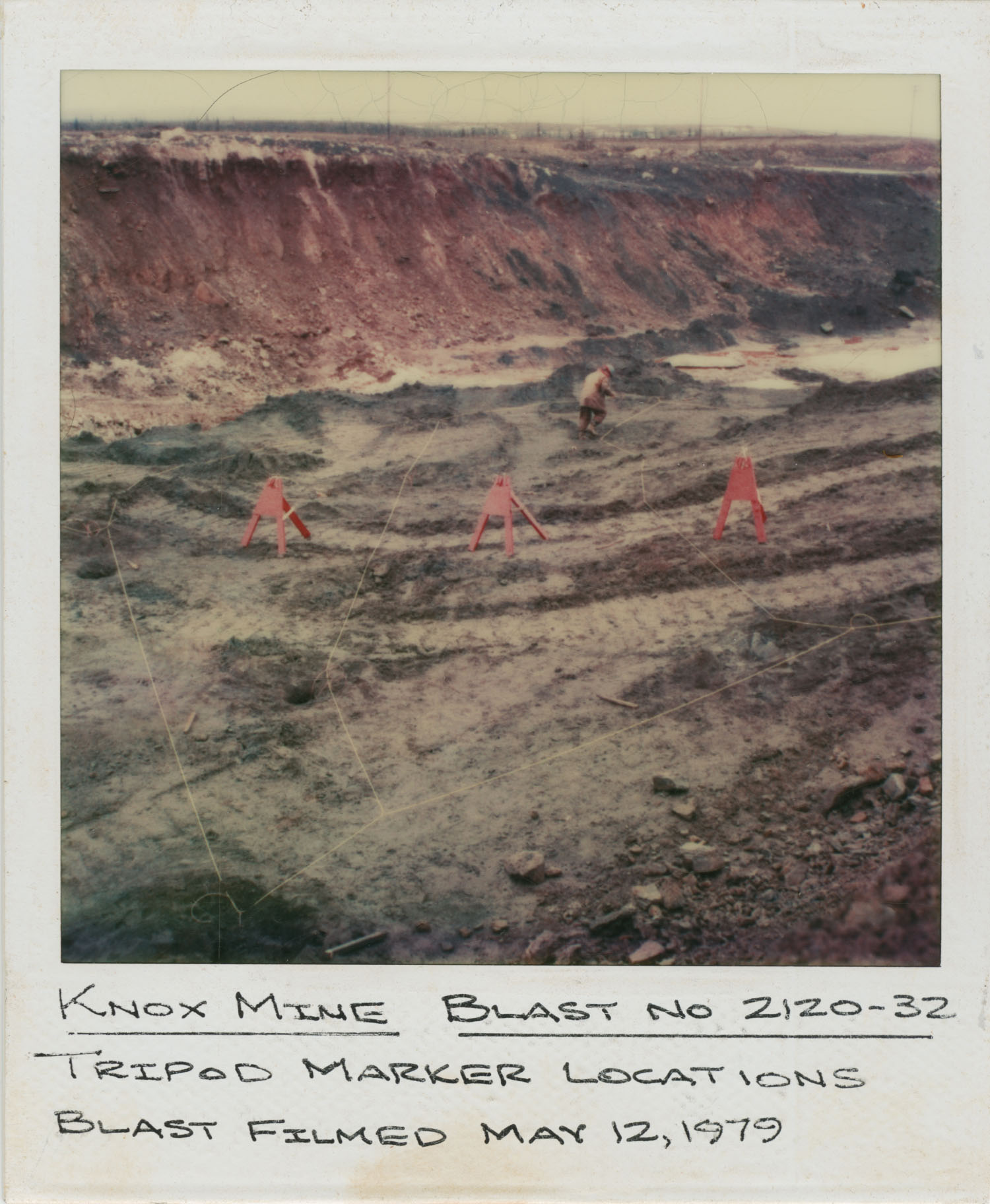 Figure 6 Preparations for high-speed photography of the blasting process in an open pit mine at Knox Mine, Schefferville. (Image author unknown).
The MSARS archive narrates and presents a history of extraction through its own visuality and aesthetics. Produced and curated by scientists, mining companies, government officials, and agencies and mediated by optical technologies such as aerial photography and other forms of photogeology, these images carry multiple values and meanings. On one hand, they possess documentary value, as they document mining activities primarily for this purpose. On the other hand, these images were created with specific functions in mind. Extending a concept already used by the German artist-filmmaker Harun Farocki, Parikka proposes the term ‘operational images’ to analyse images produced at the intersection of an ‘ecology of observation, analysis and surveillance’ (2023: vii):
Operational images are not necessarily representational or pictorial, as their primary function is to operate. Operational images trouble what an image is, as they shift from representational to nonrepresentational, from the primacy of human perception of bodies, movement and things to measurement, pattern analysis, navigation, and more. They change the scales and terms of reference. Such images have an epistemic force, while they also are involved in an intervention in the world, whether directly or indirectly (2024, p.vii).
Drawing from Parikka’s work, I suggest that the MSARS images are indeed operational images: they measure, analyse, and support the navigation of the territory from a geological perspective. They possess epistemic force, as they underpin extractive activities while also providing evidence and data for further scientific research. Furthermore, by serving governmental and corporate actors, they contribute to the creation of a specific way of conceptualising, seeing, and even directly or indirectly intervening in the world. Instead of merely representing the territory, they are produced to highlight selected patterns and measures in preparation for further interventions.
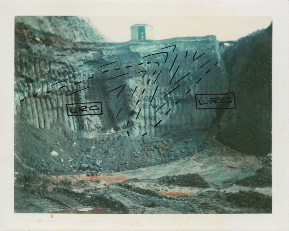 Figure 7 Some of the images in the MSARS archive were used as working tools to identify geological formations in preparation for mining activities. This photo includes notations regarding rock shape and lines that will be used for further geological interventions. (Image author unknown).
A productive approach to deepening the understanding of the MSARS images is to combine Parikka’s notion of operationality with the concept of legibility, which Scott (1998) defines as a central feature of modern statecraft and governmentality:
How did the state gradually get a handle on its subjects and environment? (…) In each case, officials took exceptionally complex, illegible and local social practices and created a standard grid whereby it could be centrally recorded and monitored. The organization of the natural world was no exception. All seemed calculated to make the terrain, its products, and its workforce more legible – and hence manipulable – from above and from the center. (…). These state simplifications, the basic givens of modern statecraft, were rather like abridged maps. They did not successfully represent the actual activity of the society they depicted (or of the territory), nor they were intended to: they represented only the slice of it that interested the official observer. They were, moreover, not just maps. Rather, they were maps that, when allied with state power, would enable much of the reality they depicted to be remade (1998: 2–3).
It is through the production of these grids, these ‘abridged maps of legibility’ that modern states pursued increased and more efficient governmentality of territories, and, by extension, of their human and more-than-human inhabitants. One of the core principles guiding legibility, according to Scott, (1998) is modern states’ ‘high modernist ideology’: an unbounded confidence in scientific and technical progress and in the fantasy of mastery of nature. Circling back to the first section of this paper, ‘high modernist ideology’ provides an accurate description of Canada’s settler colonial efforts in ‘developing’ and ‘taming’ its northern, ‘harshest’ territories through the establishment of extractive infrastructures and outposts such as mining towns.
Legibility and Operational Images: Ruptures, Exclusions, and Dispossessions
Geissler (2016, 2023) describes the former Amani Research Station in Tanzania as ‘a heterogeneous assemblage of architecture, landscape, and apparatus that accumulated traces of different sciences, and of imperial conquest, colonial development and welfare, of a specific, settler colonial mould’ (2023: 168).
Similarly, the MSARS and its material archive represent layered remnants of Canadian science shaped by a specific settler colonial mould, one that is both a product of and (re)produces practices privileging operationality and legibility. However, while these processes are extremely beneficial from a state and corporate perspective, the production of operational images and increased legibility incurs significant costs. Scott (1998) highlights that legibility and high modernist ideology necessitate the exclusion of local, embodied knowledge—knowledge that tends to complicate and render things illegible, thereby diminishing their functionality. In fact, these exclusions are often translated in aesthetics terms, as proponents of high modernism tend to favour a visual rational order, producing images that appear ‘orderly and clean’ (Scott 1998). These inclusions and exclusions shape the images and are, in turn, shaped by them, creating a complex feedback loop affecting both the images themselves and our mind’s perception of realities (Schuppli 2016). Macarena Gomez-Barris, in her analyses of the visuality of extraction, proposes the concept of the ‘extractive view’ to refer to ‘state and corporate logics that map territories as commodities rather than perceive the proliferation of life and activities that make up the human and nonhuman planetary’ (2017: 1).
Similar to Scott’s concept of legibility, the extractive view is characterised by a narrowing of perspective regarding the resourcification of territories, thereby marginalising not only local knowledges but also what she refers to as ‘social ecologies’—the complexities and relationalities that constitute humans and more-than-human worlds. Building on Gomez-Barris’s extractive view and extending it through Parikka and Scott’s arguments, this paper suggests that operationality, legibility, and the institutional production of abridged, abstracted maps are central features of visual extractivism. Furthermore, the concept of visual extractivism problematises the links between settler visualities, legitimisation of settler colonialism, land dispossession, disrupted indigenous relationalities to land, and the exclusion of local knowledge. Tentatively, visual extractivism is defined as an aggregate of technologies, aesthetics, practices, and productions that prioritise resourcification, operationality, and legibility, while simultaneously excluding situated and embodied knowledge, thus erasing the complexities and relationalities of the human and more-than-human lives that constitute social ecologies. In the context of this research, visual extractivism entails actively participating ‘in this process of dispossession directed at severing Indigenous people from their lands and territories (…): the vertical map, the survey and the legal geographies of property’ (Harris 2004: 179).
Conclusion: Towards Remediation
In summary, I sketch conceptual and creative remediation strategies as ways to further expose and question visual extractivism. Conceptually, I draw inspiration from discussions on remediation in the mining context and media theory; its creative counterpart is inspired by the work of visual practitioners in the fields of visual anthropology and visual arts.
In the mining context, remediation is part of the extractive process: it starts at the end of extraction and addresses the aftermath of extractive activities. In this sense, remediation is generally understood as the process of cleaning up or repairing the environmental damage caused by extractive activities, thus assigning a certain value to it.
‘It is generally seen as “doing the good” and is less amenable to political or ethical challenges based on community concerns and values’ (Keeling and Beckett 2019: 217).
However, from a technical perspective, remediation deals exclusively with post-extractive environments (Li 2007, in Keeling and Beckett 2019). To counter the narrowness and increasing technicality of mining remediation processes, scholars have argued for an expanded definition of the concept—one that includes notions of social justice, repair, mediation, reconciliation, and care. More specifically, remediation, as a form of mediation, can be used to address harmful relationships between humans, more-than-humans, and land while also reforming these relationalities themselves (France 2008). In the context of media studies, remediation generally refers to formal interventions that indicate the option of (re)mixing different media (Bolter and Grusin 1999). Recently, media studies scholars and archival researchers have argued for a more intentional, deeper meaning of the term. Chatterjee (forthcoming) suggests understanding archival remediation as a practice involving the ‘thickening’ of archival objects with references and context, particularly in the context of colonial archives, by initiating a process of reinserting silenced histories and local knowledge. In doing so, remediation intervenes in how we not only see anew but also feel towards these objects.
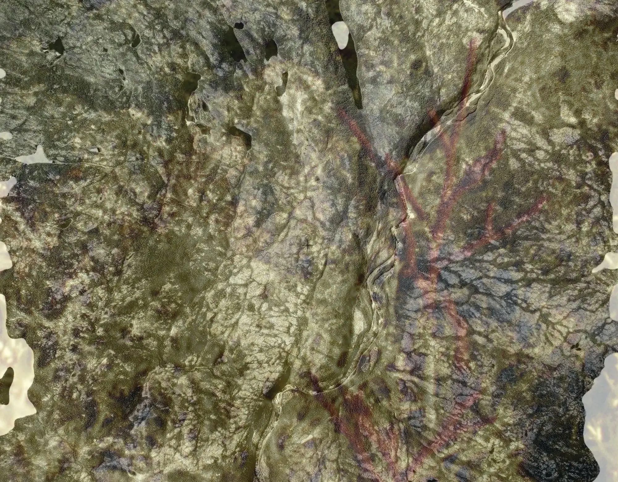 Figure 8 Above is a double exposure created by the author by superimposing the archival aerial photograph from page 2 and an image of a lichen photographed by the author. Lichens are important features of the territory in Schefferville and Matimekush, known by their human and more-than-human inhabitants. These organisms are characters in many Innu poems and stories, and they are also the main source of nutrients for caribou, animals that have been extremely important in the life and culture of the Innu. The superimposition through which the image is created is inspired by the vignette reported on pages 2-3, and sketches one possible output of the remediation described in this paper.
Expanding on the different directions and understandings that emerge from remediation, both in the context of mining and media studies, I suggest that remediation offers a powerful means of further exposing and problematising visual extractivism. Conceptually, the potential of remediation to reform relationships between territories and their inhabitants directly addresses the need to acknowledge local, embodied, and site-specific knowledge that is excluded by visual extractivist practices. Moreover, by proposing to engage with remediation not only as a concept but also as a practice, I suggest experimenting with archival remediation strategies as creative, multimodal interventions that directly address the aesthetics of images and the ways in which these affect our ways of seeing and feeling. The fundamental shift here is from operationality, legibility, and other exclusive practices fundamental to visual extractivism to possibilities of a renewed, affective perception that can ‘perceive local terrains as sources of knowledge, vitality, and livability’ (Gomez-Barris 2017: 1), thus creating spaces for multiple, shared, and inscribed perspectives that question the dominant and exclusionary narratives of visual extractivism.
In conclusion, I present below a short clip edited from material shot during fieldwork. It is an excerpt from a longer filmic work, still very much in progress, which engages with some of the questions discussed herein, namely, visual extractivism and remediation. By proposing an additional mode to the visual work that accompanies the written piece, the audiovisual excerpt expands upon the double exposure image presented above (Figure 8) and its caption. It is also introduced by a short ethnographic note that provides context for its making, pointing to the potential of experimenting with filmic remediation as a means to address and foreground the relational narratives evacuated by visual extractivist practices.
°°
One morning, L. asked me if I could help her find some pine leaves for the sapinage of the community’s shaputuan. I gladly accepted, as I really enjoyed spending time together in the forest. L. brought me to ‘the best forest’ around town, where she said, the trees are taller and the lichens are the most beautiful, lush, and gentle to touch. She told me that her father used to bring her to this place, and whenever she comes here, she feels his presence all around.
Film 1 Burnt Creek Excerpt (Bordoli 2024)
Acknowledgements
First, this work has been made possible by the people who allowed me to share moments and experiences during fieldwork. In the context of this paper, I could not elaborate on how collaboration, in the sense of the reciprocal establishment of intimate and trustful relationships, has been the fundamental layer of my research. I also thank my colleagues at the Social Anthropology Department of the University of Bern for their careful reading and McGill University’s Anthropology Department in Montréal for hosting me during the initial stages of my research. I am grateful to the Swiss National Science Foundation for funding my research and part of my fieldwork through the Sinergia Project ‘Mediating the Ecological Imperative: Formats and Modes of Engagement’ (https://ecological-imperative.ch/), as well as the Swiss Polar Institute for their support through the Polar Access Grant. This publication is also based on work from COST Action CA20134, supported by COST (European Cooperation in Science and Technology) and more specifically from TRACTS Multimodal Training School ‘Archival Memories: Image, Sequence, Knowledge’ hosted by ReCNTR at Leiden University. I especially thank Lee Douglas, from Goldsmiths University for kindly inviting me to be part of this special issue. Finally, I thank Louise Malé-Mole for allowing me to use some of her drawings in the film excerpt presented in this paper.
Notes
- 1)
- For further information concerning the Innu’s territoriality, see Cassell (2021).
- 2)
- Although my research focuses specifically on the Innus of Matimekush-Lac John, it is important to mention that there is a second native community in the region: the Naskapi community of Kawawachikamach, located approximately 20 kilometres northeast of Schefferville and Matimekush-Lac John.
- 3)
- Although this paper critiques a specific form of visuality by highlighting the relationships between extractivism, settler colonialism, and Western science (geology), it does not develop discussions concerning my own positionality as an anthropologist, researcher and visual practitioner. In addition, while I acknowledge that anthropology, along with other disciplines, has participated in the settler colonial project in Canada and elsewhere, I will not elaborate on these questions here. Ultimately, I do not claim that the remediation strategies suggested at the end of this paper can even remotely be as effective as an acknowledgment, or, pushing things further, a restitution, of indigenous land. However, I hope that this proposition contributes to making a small step towards recognising some of the consequences of extractivism and settler colonialism on ecologies, communities and indigenous territories, especially in the specific site of Schefferville and Matimekush-Lac John.
- 4)
- For more historical information on the foundation of Schefferville and the development of iron-ore resources in the region, see Boutet (2012), Keeling and Sandlos (2015), and High (2023). For a specific history of the Iron Ore Company of Canada, see Geren and McCullogh (1990). From a Native perspective, see Kapesh, A.A. (1976); https://www.nametauinnu.ca/en/home.html; https://naskapi.ca/people/past/
- 5)
- These processes were embedded in a larger project legally framed by the creation of the Indian Act in 1876, a federal, nationwide project that included the establishment of Native reservations, residential schools, and other enterprises aimed at assimilating and erasing Native communities and cultures, and fundamentally disrupting their relationships to land.
- 6)
- Both the Mid-Canada Line outpost and the Royal Canadian Air Force base were later closed down, and today, that same terrain is occupied by the small but busy Schefferville Airport.
References
- Acosta, A.
- 2020
- Extractivism: The Curse of Plenty. In Vivares, E. (ed.) The Routledge Handbook to Global Political Economy: Conversations and Inquiries, pp. 391–407. London: Routledge.
- Adams, P.
- 2007
- Trent, McGill, and the North: A Story of Canada’s Growth as a Sovereign Polar Nation, Peterborough: Cover to Cover Publication Services
- 2014
- Sixty Years of Polar Research and Teaching: The McGill Subarctic Research Station. Arctic 67(1): 124–131.
- Azoulay, A. A.
- 2019
- Potential History: Unlearning Imperialism. London, New York: Verso.
- Beckett, C. and A. Keeling
- 2019
- Rethinking Remediation: Mine Reclamation, Environmental Justice, and Relations of Care. Local Environment 24(3): 216–230.
- Bolter, J. D. and R. Grusin
- 1999
- Remediation: Understanding New Media. Cambridge: MIT Press.
- Boutet, J-S.
- 2012
- Développement ferrifère et mondes autochtones au Québec subarctique, 1954–1983. Recherches amérindiennes au Québec 40(3): 35–52.
- Bradbury, J. H.
- 1979
- Towards an Alternative Theory of Resource-Based Town Development in Canada. Economic Geography 55(2): 147–166.
- 2005
- The Rise and Fall of the « Fourth Empire of the St. Lawrence » : The Québec-Labrador Iron Ore Mining Region. Cahiers de Géographie Du Québec 29(78): 351–364.
- Bradbury, J. H. and I. St‐Martin
- 1983
- Winding Down in a Quebec Mining Town: A Case Study of Schefferville. Canadian Geographies/Géographies Canadiennes 27(2): 128–144.
- Braun, B.
- 2000
- Producing Vertical Territory: Geology and Governmentality in Late Victorian Canada. Ecumene 7(1): 7–46.
- Cassell, E.
- 2021
- The Terms of Our Surrender: Colonialism, Dispossession and the Resistance of the Innu. London: University of London Press.
- Chagnon, C.W. et al.
- 2022
- From Extractivism to Global Extractivism: The Evolution of an Organizing Concept. The Journal of Peasant Studies 49(4): 760–792.
- Collier Jr., J. and M. Collier
- 1986
- Visual Anthropology: Photography as a Research Method. Revised and Expanded ed.Albuquerque: University of New Mexico Press.
- Coulthard, G.S.
- 2014
- Red Skin, White Masks: Rejecting the Colonial Politics of Recognition (Indigenous Americas). Minneapolis: University of Minnesota Press.
- Derbyshire, E.
- 1961
- Knob Lake: A Field Research Centre. The Geographical Journal 127(3): 340–343.
- Drummond, R. N., J. D. Ives and W. G. Mattox
- 1962
- Knob Lake Field Research Centre. The Geographical Journal 128(1): 125–126
- France, R. L.
- 2008
- Healing Natures, Repairing Relationships: New Perspectives on Restoring Ecological Spaces and Consciousness. Sheffield, Vermont: Green Frigate Books.
- Geissler, P. W.
- 2023
- A Failing Anthropology of Colonial Failure: Following a Driver’s Uniform Found at Amani Research Station, Tanzania. Journal of the Royal Anthropological Institute 29(S1): 167–189.
- Geissler, P.W. and A. H. Kelly
- 2016
- Field Station as Stage: Re-Enacting Scientific Work and Life in Amani, Tanzania. Social Studies of Science 46(6): 912–937.
- Geren, R. and B. McCullogh
- 1990
- Cain’s Legacy: The Building of Iron Ore Company of Canada. Quebec: Iron Ore Company of Canada.
- Gómez-Barris, M.
- 2016
- Inverted Visuality: Against the Flow of Extractivism. Journal of Visual Culture 15(1): 29–31.
- 2017
- The Extractive Zone: Social Ecologies and Decolonial Perspectives (Dissident Acts). Durham: Duke University Press.
- Gudynas, E.
- 2021
- Extractivisms: Politics, Economy and Ecology. Halifax: Fernwood Publishing.
- Harris, C.
- 2004
- How Did Colonialism Dispossess? Comments from an Edge of Empire. Annals of the Association of American Geographers 94(1): 165–182.
- Heidt, D, and P.W. Lackenbauer
- 2022
- The Joint Arctic Weather Stations: Science and Sovereignty in the High Arctic, 1946–1972. Calgary, Alberta: University of Calgary Press.
- High, S.
- 2023
- With Iron We Conquer: Deindustrialization, Settler Colonialism, and the Last Train out of Schefferville, Quebec. Canadian Historical Review 104(1): 50–75.
- Kapesh, A. A.
- 2019 [1976]
- Eukuan Nin Matshimanitu Innu-Iskueu [Je Suis une Maudite Sauvagesse], Québec: Mémoire d’encrier.
- Keeling, A. and J. Sandlos (eds.)
- 2015
- Mining and Communities in Northern Canada: History, Politics, and Memory. Calgary, Alberta: University of Calgary Press.
- Peyton, J. and A. Keeling
- 2017
- Extractivism and Canada 150, Critical Historical Geographies 45(1): 117–124.
- Rodon, T., A. Keeling, and J.-S. Boutet
- 2022
- Schefferville Revisited: The Rise and Fall (and Rise Again) of Iron Mining in Québec-Labrador. The Extractive Industries and Society 12
- Schuppli, S.
- 2016
- Dirty Pictures. In M. Belina (ed.) Living Earth: Field Notes from the Dark Ecology Project 2014–2016, pp. 190–208. Amsterdam: Sonic Acts Press.
- Scott, J. C.
- 1998
- Seeing like a State: How Certain Schemes to Improve the Human Condition Have Failed. New Haven: Yale University Press.
- Serafini, P.
- 2023
- The Visual Politics of Extractivism. In A. Veneti and M. Rovisco (eds.) Visual Politics in the Global South(Political Campaigning and Communication), pp. 239–255. Cham: Palgrave Macmillan.
- Simpson, L. B.
- 2021
- As We Have Always Done: Indigenous Freedom Through Radical Resistance. Minneapolis: University of Minnesota Press.
Websites
- Paulo Tavares
- 2024
- https://www.paulotavares.net/ (accessed May 30, 2024)
- [Re:]Entanglements
- 2024
- https://re-entanglements.net/ (accessed May 15, 2024)
- Sky Hopinka
- 2024
- https://www.skyhopinka.com/ (accessed April 5, 2024)
Films
- Bordoli, A.
- 2024
- Burnt Creek Excerpt. University of Bern, 2:09.
https://vimeo.com/1020492953/cefe427e80 (Retrieved March 27, 2025)
Websites
Andrea Bordoli
https://andreabordoli.ch